Articles
The post–1950 emergence of Kuala Lumpur as a great Southeast Asian city

Professor Gregg Huff, Pembroke College, University of Oxford

Kuala Lumpur lacks the locational advantages of Southeast Asia’s great cities and yet it has come to rank among them. The main aim of this article is to analyse post-1950 growth of Kuala Lumpur and explain the city’s rise. This article argues that political considerations as much as economic factors account for the emergence of Kuala Lumpur as a mega-city and its dominance in Malaysia, despite that country being easily the most urbanized in Southeast Asia. In 2020, over three quarters of Malaysians lived in cities. In so urban a country, one might anticipate a Kuala Lumpur having a far less commanding position than it does, and a city distribution more in accordance with a Zipian, or rank-size, criterion in which the second largest city has half the population of the first, the third most populous a third of the people in the largest city and so on.

The great cities of late 19th- and early 20th-century Southeast Asia—Rangoon (Yangon), Bangkok, Singapore (for all of Malaya), Jakarta, Manila and Saigon-Cholon (Ho Chi Minh City)—had ‘first nature’, or geographical, advantages of optimal or near optimal sites for ports to link the largest possible primary-goods-producing hinterland to international markets. These cities functioned as ‘gateways’ to the world. On this basis, the cities grew through ‘second nature’, or built, advantages of infrastructure and commercial and financial networks. Through functioning as growth poles, the cities attracted investment and people. By 1950, each of these cities was dominant in its own country, which for Malaya effectively meant Singapore even though the two cities were now in different political jurisdictions.

To be sure, Kuala Lumpur, like any large city, did not grow by accident. But its initial locational advantages were the relatively modest ones of being at the conjunction of two rivers—Klang and Gombak—and affording access to Selangor’s rich tin fields. The small costal port of Port Klang (originally Port Swettenham), about 30 kilometres from Kuala Lumpur, provided the outlet from which it could ship tin to Singapore and receive return flows of goods. In the 20th century, Kuala Lumpur grew as a railway town and as a centre in the Federated Malay States for the rubber industry. Even so, in 1947 Kuala Lumpur was still a relatively small, a Chinese city and decidedly provincial. It had a population of 176,000, a quarter of Singapore’s and in size trailed far behind Southeast Asia’s great cities (Table 1).

Table 1 Kuala Lumpur and Singapore population, 1931–2018


Notes: The article uses ‘urban agglomeration’ to mean a ‘population contained within the contours of a contiguous territory inhabited at urban levels of residential density’, and regards this as synonymous with the term city and as defining a city’s boundaries. A ‘metropolitan area’ or ‘metropolitan agglomeration’, also sometimes described a mega-urban region or even simply as a city, ‘comprises an urban agglomeration and surrounding areas at a lower settlement density with strong economic and social linkages to the city’.
In the table, ua denotes urban agglomeration, and ma metropolitan area. (UNDESA, 2018a, p. 5; UNDESA, 2018b, p. 1).
Sources of data: Hamzah Sendut (1965, p. 128); Huff, G. (1994, p. 158 and p. 292); (UNDESA, 2018b).

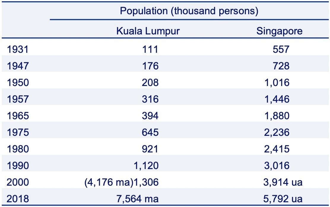
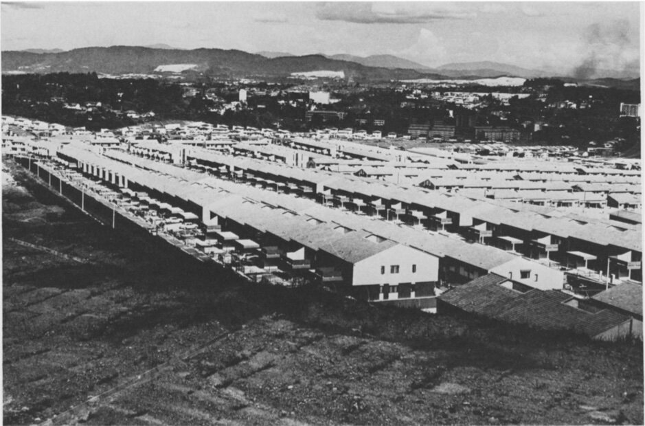
Growth of Kuala Lumpur

At the time of Malaya’s independence in 1957, Kuala Lumpur remained a relatively small city of 316,000 (Table 1). Its new capital and largest city was still a 'Chinese town with a colonial overlay’ (Rimmer and Howard, 2009, p. 62). More than three fifths of the population were Chinese. Despite some post-World War II gains, just 15.9 per cent Malay, although Malays comprised 49 per cent of the population of Peninsular Malaya (Table 2). Buildings of over 10 storeys had started to appear in the central business area only in the 1960s and modern offices to displace shop-houses. A single office building often took the space of several shop-houses (Hamzah Sendut, 1965, p. 135).

Table 2 Kuala Lumpur and nearby areas ethnic composition of the population of Malaysian citizens, 1957–2022
Note: a 2022 data are population estimates made by the Department of Statistics–Malaysia.
Sources of data: Fell (1959, p. 3); Khoo (1983, pp. 226–227); Shaari Abdul Rahman (2001, p. 47); Department of Statistics–Malaysia (2023, p. 74).


For Kuala Lumpur, and most of Southeast Asia’s other principal cities, the urban growth pattern proceeded through the formation of conurbations as urbanization spread from a central area along dominant ribbon roads axial to main roads leading into and out of the city. Development along these ribbons reproduced on a small scale the businesses of the centre, served surrounding residential areas, and acted as ‘neighbourhood’ shopping centres. A conurbation formed as new housing estates appeared adjacent to ribbon roads and were incorporated in the city, and as it further extended to include surrounding villages and towns. Subsequently, cities, now with high rise office building and banks emerging as dominant features of the city centre grew yet more to encompass surrounding towns and infrastructure. Through repeating the process, Kuala Lumpur, and other once colonial cities, became urban agglomerations or extended to metropolitan areas, either one of which might be of several million people.1 

By the mid-1960s, the beginnings of a Kuala Lumpur conurbation were apparent as the municipal boundary expanded outwards in all directions. Greater Kuala Lumpur extended to the north and south through ribbons of building along Pudu Road and Jalan Tunku Abdul Rahman and to the east and west to envelop rubber estates and abandoned tin mining land, both re-developed as housing estates (Figures 1, 2, 3 and 4). The cheapness of disused tin-mining land and lack of major physical barriers encouraged lateral extension.

Figure 1 Central Kuala Lumpur street pattern, 1965
Source: Based on Hamzah Sendut, (1965), pp. 125–38., p. 131.


Figure 2 Kuala Lumpur early 1960s
Source: Hamzah Sendut (1965, p. 133).


Figure 3 Kuala Lumpur central business district, mid 1960s
Figure 4 Kuala Lumpur area adjacent to Petaling Street and Jalan Sultan Junction, 1965
Street scene in the central business area of Kuala Lumpur city, Permanent Mission of the Government of the Federation of Malaya to the United Nations.
Source:
Hamzah Sendut (1965, p. 132).


Views of Kuala Lumpur looking north, showing the area adjacent to Petaling Street and Jalan Sultan Junction.
Source:
Hamzah Sendut (1965, p. 131).


Petaling Jaya, established in 1953 and 12 kilometres from Kuala Lumpur, was the first of Malaysia’s new towns. The original plan was that Petaling Jaya would serve as an overspill for some of the (by then large) population in Kuala Lumpur’s squatter and overcrowded areas (Concannon, 1955, pp.41–43). However, Petaling Jaya developed as a middle-class suburb. So, too, did a large number of other new towns, all satellites to Kuala Lumpur, built soon after Petaling Jaya. In the mid-1970s, Petaling Jaya was among Peninsula Malaysia’s most industrialized towns. Shah Alam, a new town planned in the mid-1960s and well established a decade later, facilitated a formative urban corridor between Kuala Lumpur and Port Klang. More than a fifth of the town’s 7,539 acre site was an industrial area (Lee, 1996, p. 364). Similarly, other new towns, because of nearness to the Kuala Lumpur market, typically provided industrial zones, as well as housing, shopping, and leisure (Figure 5) (Aiken and Leigh, 1975, pp. 549–554; Hamzah Sendut, 1965, pp. 136–138).

In 1963, following the extension of Kuala Lumpur’s boundaries, the city encompassed Malay rural villages, Chinese ‘new villages’ and segregated squatter areas, totalling some 100,000 people or about a quarter of the ‘urban’ population (Rimmer and Howard, 2009, p. 62). Closely-packed terraced housing accommodated a further significant share of the city’s population (Figure 5).

Figure 5 Kuala Lumpur terraced housing, 1975
Closely spaced terraced housing at Bungsar Baru, Kuala Lumpur. The houses have almost no front yards, and at the back open directly onto narrow lanes. The white scars on the hills in the distance are housing development areas in southeastern Kuala Lumpur
Source:
Aiken and Leigh (1975, p. 561).


From the 1960s onwards, Kuala Lumpur continued to increase its size by expanding to encompass other urban or quasi-urban areas over a substantial part of the country’s wealthiest region, leaving other large Malaysian cities well behind as urban rivals. by 1975, it was clear that Kuala Lumpur would stretch along corridors of some 30 miles over the Klang Valley to form a metropolitan area, which would include Port Klang (Figure 6).

Figure 6 Kuala Lumpur metropolitan area (Klang Valley), 2020
Source: Based on Mohd Uzir Mahidin (2024).


The spread of Kuala Lumpur incorporated many villages designated by the 1913 Land Enactment Act as Malay reservations. The Act was intended to preserve the Malay lifestyle of traditional subsistence and cash-crop activities by preventing Malays from selling their land except to other Malays. Yet for the villages, reservation land and Kuala Lumpur’s encroachment undermined an earlier Malay way of life and left poor and deprived areas. Villagers were drawn away to more remunerative, city work, and the acquisition of land for cultivation became uneconomic, because the possibility of future urban development raised village land values above levels economical for farming. However, the restrictions on the sale of land kept its values below those in nearby unrestricted areas. The relative cheapness of land encouraged non-local Malays to crowd into the villages which came to resemble Kuala Lumpur’s squatter settlements, not suburban development (Brookfield, et. al., 1991).

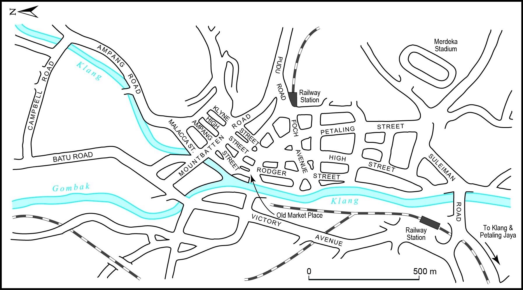
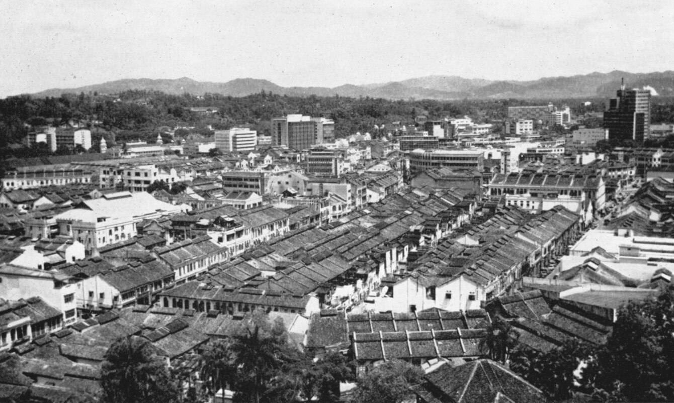
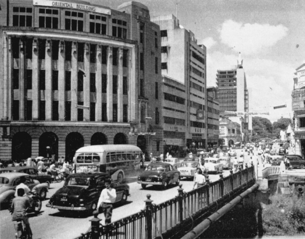
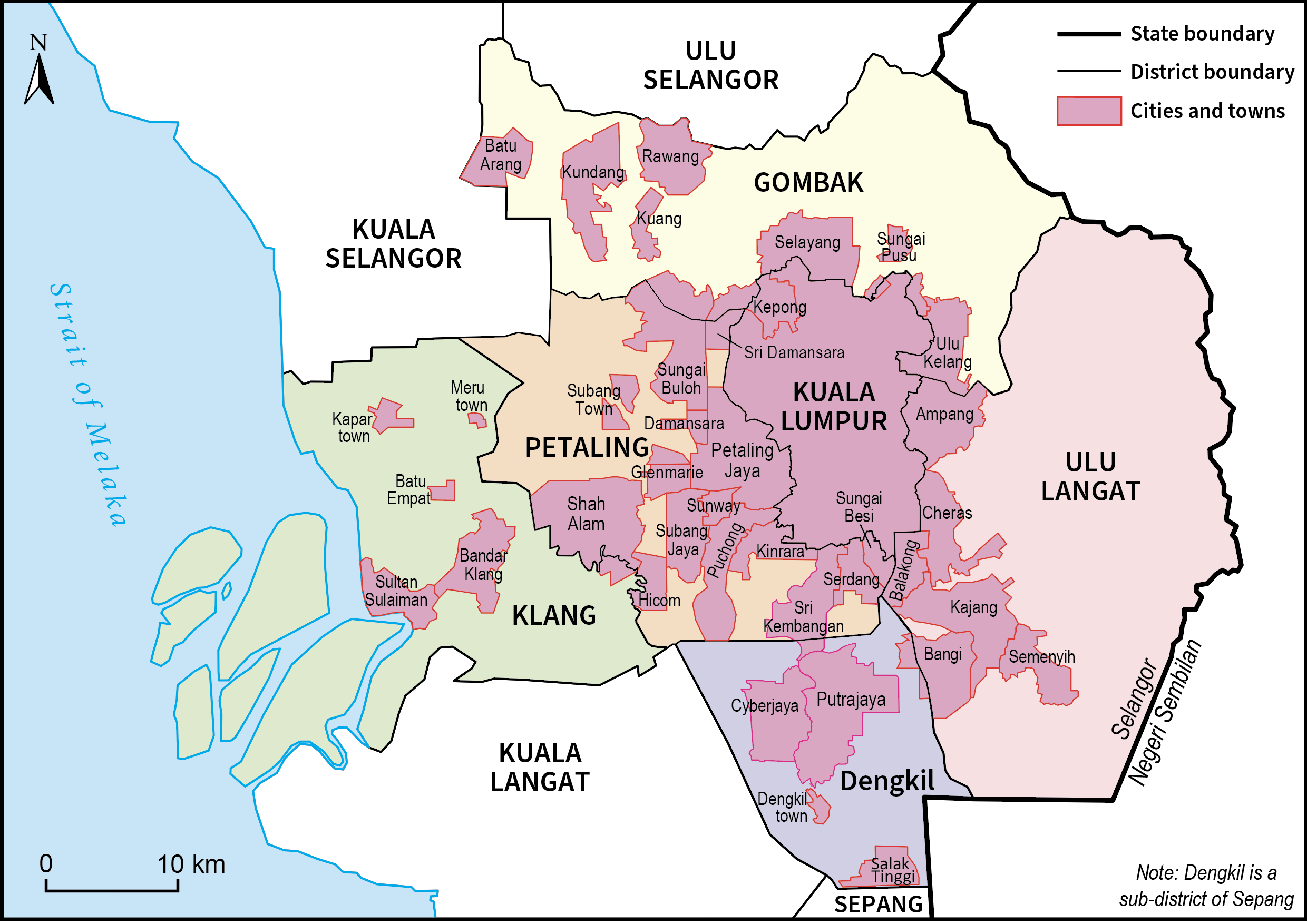
Kuala Lumpur: a primate city

In 1950, all of Southeast Asia’s main cities were also primate cities, in being at least twice the population size of the second city. Most of Southeast Asia’s main cities had from four to over eight times as many inhabitants as the second largest city. In Malaya, Singapore, not Kuala Lumpur, still functioned as in effect the primate city (Table 1).

Between 1950 and 2018 within Southeast Asia, two contrasting patterns of primacy are evident. One is that by 2018, as for Manila, Bangkok and Yangon, primacy declined as urban systems filled in and the diseconomies associated with the largest urban areas stimulated, at least somewhat, the growth of their second-city counterparts. Nevertheless, the gaps between first and second cities remained quite large.

For Kuala Lumpur, a second, divergent pattern of increasing primacy was apparent. Political power, as often in developing countries, was fundamental to Kuala Lumpur’s growth (Ades and Glaeser, 1995, pp. 195–227; Davis and Henderson, 2003, pp. 98–125). Centralizing effects operated both through an expansion of government and the importance of the largest city, especially if also a capital, as a place where political favours are dispensed and things get done. The assumption of enhanced administrative and political roles for Kuala Lumpur as the capital city in a newly independent country drew in population. The same was true of Jakarta and of Hanoi after Vietnamese re-unification in 1975.

Kuala Lumpur’s population grew between 1960 and 2018 at a rate implying a doubling in size about every 13 years. Such rapid expansion can only be fully explained by political decisions. After Malaysian independence in 1957, Kuala Lumpur was the centre of the new government and it was free to promote the city’s development as a matter of policy. Independence in 1957 was followed by an infusion of provincial Malays who, although a tiny minority, joined either government administrative and security services or the informal sector. Nevertheless in 1975, Kuala Lumpur remained a relatively small city of 645,000 (Tables 1 and 2). Although Kuala Lumpur was no longer, as in 1957, dwarfed by Singapore—a provincial, poor relation to its southern neighbour—neither was it the size that might be expected of the capital of a prosperous nation and Southeast Asia’s most urbanized country. In many ways, Singapore still functioned, as it had historically, as the Malay peninsula’s capital city (Hamzah Sendut, 1965, pp. 128–129; Rimmer and Howard, 2009, p. 62; and Aiken and Leigh, 1975)

After the May 1969 riots, the Malaysian government, and its New Economic Policy, took the early steps which were to lead towards developing Kuala Lumpur ‘as a capital of world standing’. In 1990, Prime Minister Mahathir Mohamad determined that Kuala Lumpur—under the New Development Policy, Vison 2000—would become a global city-region to rank alongside Singapore (Rimmer and Howard, 2009, pp. 72–75). The latter had become an international city and at least approached the goal set by Lee Kuan of being ‘the New York of the East’ (Lee, 1998 and 2000). Although Kuala Lumpur, in 2000, was well short of Singapore’s international role or ambiance, the city, as a metropolitan area, had become somewhat more populus than its rival to the south (Table 1). By then, too, central Kuala Lumpur and its nearby areas had become as much a Malay city as a Chinese one. Each ethnic group accounted for over two fifths of the population (Table 2).

Between the 1990s and early 2000s, the Malaysian government systematically planned and reshaped Kuala Lumpur with a range of mega-projects and infrastructure, notably super highways, to accommodate a spreading, road-based metropolitan area. As late as 1989, Kuala Lumpur had just two motorways and expressways. Their number increased to 20 in 2010 and 26 by 2019, facilitating rapid urbanization but also unattractive urban sprawl (Muhammad Yazrin Yasin, et. al. 2022, pp. 9–10).

Four projects are especially spectacular, modern high-rise equivalents to the world’s great cathedrals. One was the Kuala Lumpur City Centre which included the Petronas Twin Towers, completed in 2003 and the world’s then two tallest buildings; and a second the oversized Kuala Lumpur International Airport and ‘Airport City’ incorporating two new towns. The third and fourth were the 50 kilometre Multimedia Super Corridor inaugurated in 1996 (Singapore planned for its multimedia concentration in IT 2000) to accommodate high-tech activities.

Fourth, Putrajaya, a 10,000 acre ‘garden city’, was built to serve as a grand, new administrative capital and incorporated one of the world’s only grand pink mosques and acres of parkland (Figure 7). An eco-haven for birds and insects, Putrajaya has Malaysia’s largest man-made wetlands. Putrajaya, like the other three mega-projects, stood as a monument to Malay culture and the economic advance of Malaysia.

Figure 7 Putrajaya pink mosque, 2020
Source: https://www.malaysia.travel/explore/putra-mosque#:~:text=The%20mosque%20is%20constructed%20with,Persia%20during%20the%20Safavid%20period


By 2020, Kuala Lumpur had been transformed from a Chinese into a majority Malay city and approximately accorded with Malaysia’s overall racial balance, a continuation of a trend that began after independence and was intended by the government. Metropolitan Kuala Lumpur and the surrounding area (excluding non-citizens) was 48 per cent Malay, 41 per cent Chinese, and 10 per cent Indian Table 2). The composition of the Klang Valley was almost the same. In both instances, non-citizens accounted for some 9.0 per cent of the population (Mohd Uzir Mahidin, 2024).

Furthermore. Kuala Lumpur, as a metropolitan area, considerably exceeded Singapore in population, although the inclusion of some of population in Johor Bharu and Riau as part of growth generated by Singapore would narrow the size differential (Table 1). Kuala Lumpur has grown to a position of utter dominance in Malaysia. The city stands out as the Southeast Asian exception to a diminishing main city share of a country’s urban population.

Penang—if defined to include Seberang Perai, the former Province Wellesley across the causeway from the island and constituting a Georgetown-Seberang Perai metropolitan agglomeration—would comprise an urban area of over a million and a half. Penang’s growth gained momentum as a centre for the electronics industry, but the city was nevertheless easily outpaced in size by electronics and other expansion of the Kuala Lumpur-Klang Valley mega urban region.

Johore Bharu, Malaysia’s second or third city depending on the definition of Penang as a city and on how one accounts for the Johor Bahur-Pasir Gudang urban corridor, which grew from a low base, primarily through being an extension of Singapore, across the Strait of Johor. The industrial estate in Jurong, east of central Singapore and opened in 1968, provided the main site for Singapore’s early industrial development but as manufacturing for export took off, the Republic needed to obtain more land as well as cheap labour. In response, the Singapore government, in partnership with Malaysia and Indonesia, established the Singapore-Johor-Riau growth triangle, which stretched from southern Malaysia to encompass Johor Bharu, Singapore and some small Indonesian islands. By 2018, Johor Bharu, as a component of the triangle, had about a million people, but this was no more than a seventh of Kuala Lumpur’s population.

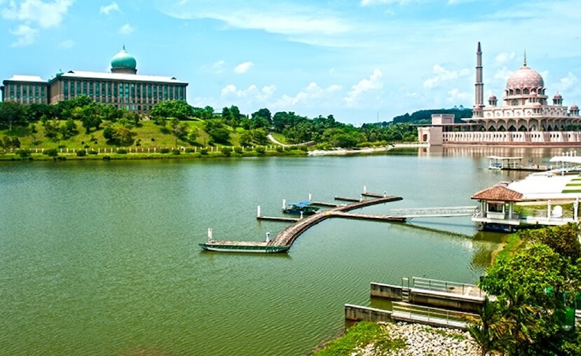
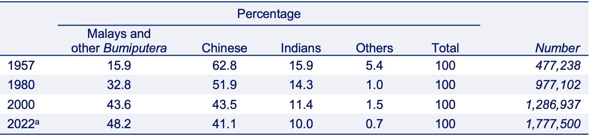
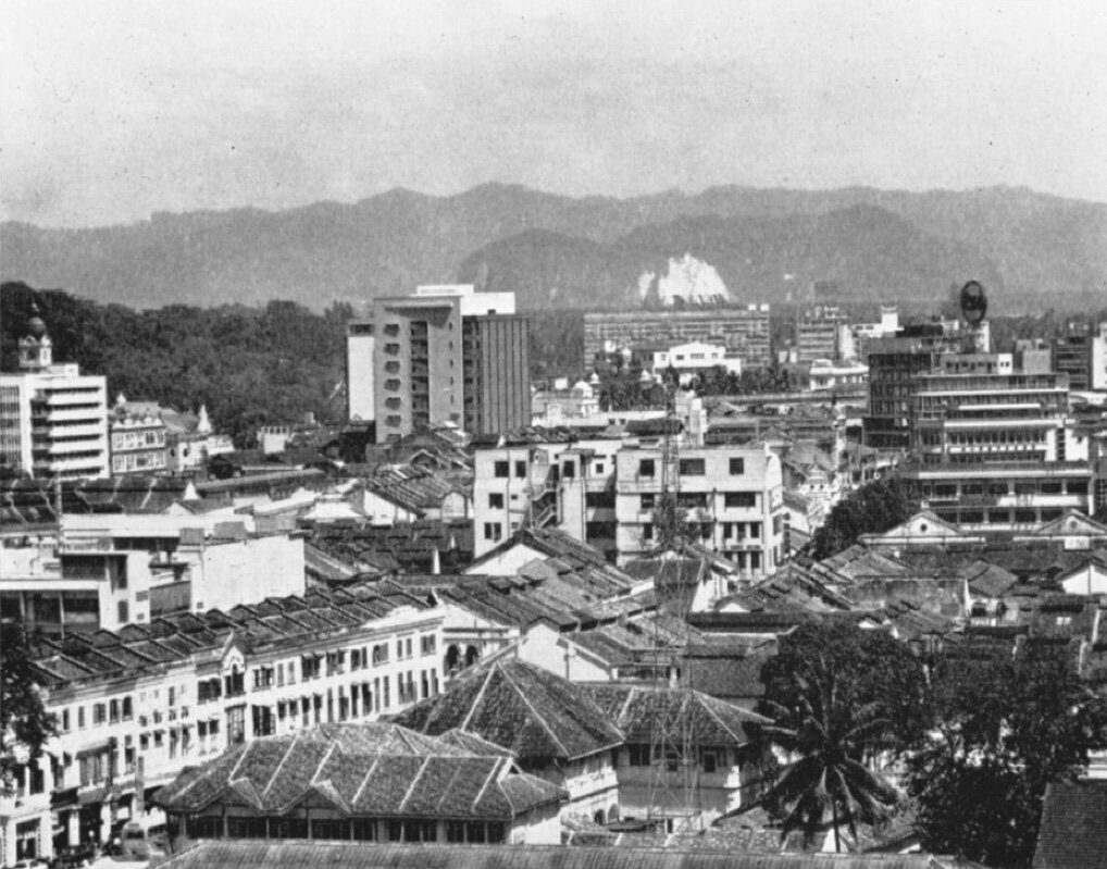
Globalization, industrialization, and growth of Kuala Lumpur

In history, urbanization and industrialization go together. Yet this became true of Southeast Asia only from the beginning of the 1950s, since before World War II, the region’s main cities had relatively little industry and grew chiefly as commercial and service centres. Because of this limited role, the region’s main cities had populations of no more than about a million by World War II or soon after.

Industrialization and the globalization, which brought inflows of foreign investment in Southeast Asian industry, were major forces in the expansion of all Southeast Asia’s main cities except Yangon. Important as politics has been in Kuala’s Lumpur’s growth, the city, like its other giant counterparts in Southeast Asia, would not have grown so large without being an industrial centre. In Southeast Asia’s main cities, people were drawn to the jobs that industry offered and with industrialization came the additional work in associated and secondary industrial development, construction, and services, all of which stimulated further cityward migration. These multiplier effects likely outweighed the jobs directly attributable to industrial employment.

After World War II, when Malaysia gained independence, industrialization became a priority, as for other Southeast Asian countries. New industrial ventures were very largely found in the region’s main cities. Both state and private investors chose to locate new ventures in these cities as growth poles which were the focus of an infrastructure of transport and communications laid down before World War II to serve export economies. Main cities afforded, as well as a country’s greatest abundance of skilled labour and supplies of power and water, the principal local market for manufactured goods.

Investors, however wrongly in the aggregate, perceived the main cities as, on balance, affording positive external economies unavailable in smaller urban areas. A clustering of industry to realize external or agglomeration economies—to overcome through nearness, in Hirschman’s phrase, the ’frictions of space’—brought yet more industrial activities as well as associated services (Hirschman, 1958, p. 197; Rosenthal and Strange, 2020, pp. 27–49).2  Industry and services created jobs and these drew in labour, although often well beyond what new employment opportunities merited. In Peninsular Malaya, Kuala Lumpur afforded the most advantages as a growth pole.

The pull of growth poles and their advantages of saving on costs was evident during Malaysia’s phase of import substitution in the new towns adjacent to Kuala Lumpur. Import substitution concentrated industry in these areas. While the city itself lacked space for industry, the new towns still gave easy access to Kuala Lumpur’s market, transport infrastructure and labour force (Howard and Rimmer, 2003, pp. 327–329).

These same pull effects of Kuala Lumpur operated with even greater force as Malaysia turned outwards to export manufactures. Malaysian industrial expansion near Kuala Lumpur has been described as ‘superinduced’: the outcome of growth-oriented ‘active strategies to attract foreign investments’ (Lee, 1995, p. 323). By 2025, the Kuala Lumpur metropolitan agglomeration, although with 30 per cent of Malaysia’s population, is expected to account for two fifths of its GDP (Muhammad Yazrin Yasin, et. al., 2022, p. 7).

It has been suggested that strong backward and forward linkages created by import substitution help explain the emergence of huge metropolitan centres in developing countries, but under trade liberalization a considerable weakening of these linkages has a decentralizing effect on urban growth (Krugman and Elizondo, 1996, pp. 137–150). While the first part of this argument accords with Malaysian experience, the second seems more doubtful, since both import substitution and export-oriented industries concentrated in Kuala Lumpur.

Conclusion

Kuala Lumpur stands as an exception to urban development in Southeast Asia; it is a story of geography as destiny, of first nature locational advantages being strongly and repeatedly reinforced by both government and private investment decisions. Before 1940 in Southeast Asia, geography largely determined the siting of ports, and government strengthened this by building urban infrastructure on these optimal or near optimal port sites to connect primary-producing hinterlands to export markets. The port locations chosen determined the pattern of Southeast Asia’s main cities. Kuala Lumpur was different: for it, Malaysian independence, not location, was crucial.

Regional dualism resulting from an emphasis on a few economic growing points within countries is a major theme in Southeast Asian economic history and one to which, for Malaysia, urbanization adds a further dimension. Starting in the 1970s in Malaysia, political choice, globalization, industrialization, and urbanization strongly reinforced one another. A centralization of political power in Kuala Lumpur and decisions that the city would rank the equal to any of the world’s cities has shaped Malaysian urbanization. Malaysian growth—as it had been during the country’s pre-1940 growth and the emergence of a dual economy—was again not balanced but starkly skewed towards imbalance.

Beginning in the 1950s, polarization effects largely prevailed, especially for manufacturing, because of a combination of political decisions and the economics of agglomeration. Malaysia remained, as throughout its pre-World War II development, a country of hugely dominant urbanization, unbalanced growth, and a dual economy. An important difference from the pre-war period is that by the 1990s Kuala Lumpur had joined Singapore as a second great city.

Further reading:

Ades, A. F. and Glaeser, E. L. 1995. ‘Trade and Circuses: Explaining Urban Giants’. Quarterly Journal of Economics, Vol. 110, No. 1, pp. 195–227.

Aiken, R. S. and Leigh, C. H. 1975. ‘Malaysia’s Emerging Conurbation’. Annals of the Association of American Geographers, Vol. 65, Issue 4, pp. 546–563.

Brookfield, H., Abdul Samad Hadi, and Zaharah Mahmud. 1991. The City in the Village: The In-situ Urbanization of Villages, Villagers and their Land Around Kuala Lumpur, Malaysia. Singapore: Oxford University Press.

Concannon, T. A. L. 1955. ‘A New Town in Malaya: Petaling Jaya, Kuala Lumpur’. Malayan Journal of Tropical Geography, 5, pp. 39–43.

Davis, J.C. and Henderson, J. V. 2003. ‘Evidence on the Political Economy of the Urbanization Process’. Journal of Urban Economics, Vol. 53, No. 1, pp. 98–125.

Department of Statistics–Malaysia. 2023. Current Population Estimates Malaysia 2023. Putrajaya: Department of Statistics–Malaysia.

Dick, H. and Rimmer, P. J. 2003. Cities, Transport and Communications: The Integration of Southeast Asia Since 1850. New York: Palgrave Macmillan, pp. 327–329.

Fell, H. 1959. 1957 Population Census of the Federation of Malaya, Report No. 2, State of Selangor. Kuala Lumpur: Department of Statistics–Federation of Malaya.

Hamzah Sendut. 1965. ‘The Structure of Kuala Lumpur: Malaysia’s Capital City’. The Town Planning Review, Vol. 36, No. 2, pp. 125–138.

Hirschman, A. O. 1958. The Strategy of Economic Development. New Haven: Yale University Press, p. 197.

Huff, G 1994. The Economic Growth of Singapore: Trade and Development in the Twentieth Century (Cambridge: Cambridge University Press). 1994.

Khoo, T. H. 1983. General Report of the Population Census, 1980 Population and Housing Census of Malaysia, Vol. 2. Kuala Lumpur: Department of Statistics Malaysia.

Krugman, P., and Elizondo, R. L. 1996. ‘Trade Policy and the Third World Metropolis’. Journal of Development Economics, Vol. 49, Issue 1, pp. 137–150.

Lee, B. T. 1995. ‘Challenges of Superinduced Development: The Mega-urban Region of Kuala Lumpur-Klang Valley’ in McGee, T. G. and Robinson, I. M. (eds), Mega Urban Regions of Southeast Asia, Vancouver: UBC Press, pp. 315–327.

______ 1996. ‘Emerging Urban Trends and the Globalizing Economy in Malaysia’, in Lo, F-C and Yeung, Y-M. (eds), Emerging World Cities in Pacific Asia, Tokyo: United Nations University Press, p. 364.

Lee, K. Y. 1998. The Singapore Story. Singapore: Times Editions Pte Ltd.

______ 2000. From Third World to First: The Singapore Story: 1965–2000. New York: Harper.

Mohd Uzir Mahidin. 2024. MyCensus 2020: Mukim/Town/Pekan. Putrajaya: Department of Statistics–Malaysia.

Muhammad Yazrin Yasin, Muhammad Azmi bin Mohd Zain and Muhammad Haniff bin Hassan. 2022. ‘Urbanization and Growth of Greater Kuala Lumpur: Issues and Recommendations for Urban Growth Management’. Southeast Asia: A Multidisciplinary Journal, Vol. 22, Issue No. 2, pp. 9–10.

Rimmer, P. J. and Dick, H. 2009. The City in Southeast Asia: Patterns, Processes, and Policy. Honolulu: University of Hawaii Press.

Rosenthal, S. S. and Strange, W. C. 2020. ‘How Close Is Close? The Spatial Reach of Agglomeration Economies’. The Journal of Economic Perspectives, Vol. 34, No. 3, pp. 27–49.

Shaari Abdul Rahman. 2001. Population Distribution and Basic Demographic Characteristics, 2000 Population and Housing Census of Malaysia. Putrajaya: Department of Statistics Malaysia.

United Nations, Department of Economic and Social Affairs, Population Division (UNDESA). 2018a. The 2018 Revision of the World Urbanization Prospects. New York: UNDESA.

______ 2018b. The World’s Cities in 2018—Data Booklet (ST/ESA/ SER.A/417). New York: UNDESA.


This study employs United Nations terminology and relies mainly on United Nations data. ‘Urban agglomeration’ means a ‘population contained within the contours of a contiguous territory inhabited at urban levels of residential density’, and the study regards this as synonymous with the term city and as defining a city’s boundaries. A mega-city sometimes denotes a city with a population of 10 million or more but here the cut-off is taken as 5 million, a level for which in 2018 all of Southeast Asia’s main cities qualified except in Cambodia and Laos. A ‘metropolitan area’ or ‘metropolitan agglomeration’, also sometimes described a mega-urban region or even simply as a city, ‘comprises an urban agglomeration and surrounding areas at a lower settlement density with strong economic and social linkages to the city’ (UNDESA, 2018a, p. 5; UNDESA, 2018b, p. 1). The fewest people live in a city proper; an urban agglomeration is larger, and a metropolitan area larger still.
Mike Shand, University of Glasgow, drew the two maps.
2 See Rosenthal and Strange (2020) on the importance of often quite near proximity.


SHARE THIS PAGE
RELATED SITES

ECONOMIC HISTORY OF MALAYA
c/o Asia-Europe Institute
University of Malaya,
50603 Kuala Lumpur

Install EHM PWA App

Ooops!
Generic Popup